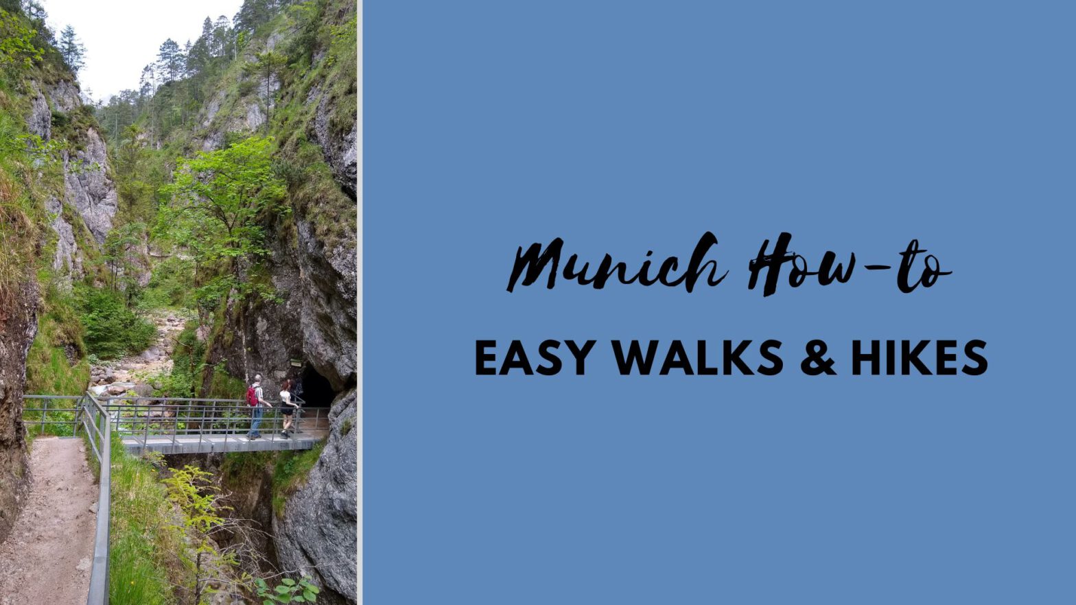
Had enough of the city? With its proximity to lakes and mountains, Munich is a great place to go for an easy hike or extended walk. In this post, I introduce you to a selection of easy hikes and walks that are all doable as a day excursion from Munich. I have been on all of them, in some cases multiple times. They are enjoyable for a reasonably fit person who is comfortable on an unpaved trail.
Personally, I am what we call a „Genusswanderer“: someone who hikes for the enjoyment, rather than for pushing my physical limits. Some of these hikes can be a bit strenuous, but I am no professional athlete, either.
All the trailheads can be reached by public transportation.
DISCLAIMER: This is a blog post based on my personal experience, not a hiking guide, and should serve for inspiration only! Please make sure to research any hike carefully and decide if it is suitable for you and your personal fitness. None of these hikes are remote, but you can still have accidents. (Trust me, I tore three ligaments when I twisted my ankle crossing the street!!)
Gmund to Tegernsee on the „Höhenweg“
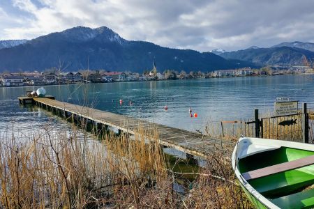
Lake Tegernsee is one of the prettiest lakes in Bavaria. It is just an hour from Munich.
BRB trains run once or twice per hour towards Tegernsee. Alight at the small town of Gmund at the northern end of the lake. Head towards the town center and lake first, then look for the signs to „Tegernseer Höhenweg“ or just ask the locals. The distance covered on the Höhenweg is about 5 kms (3.5 miles).
You will gently gain some elevation – this is not a lakeshore trail! You will initially walk on paved roads, but fairly soon you are on walking trails.
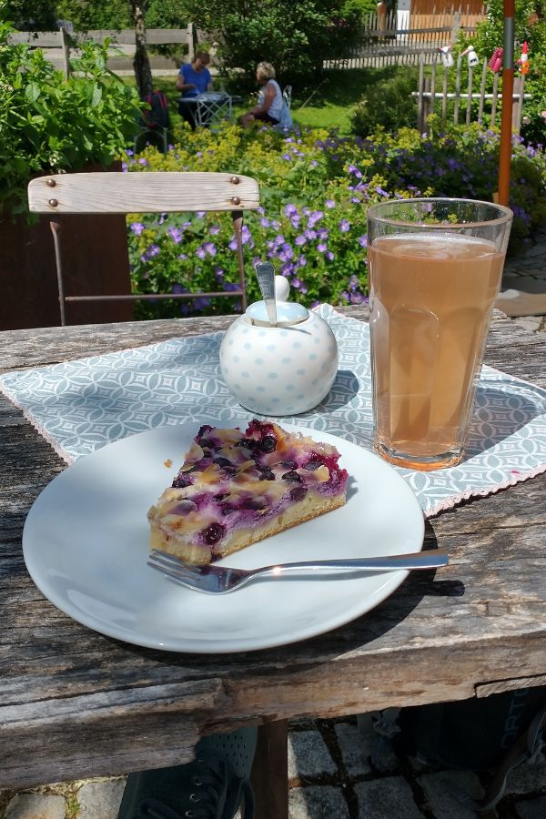
Depending on the season, you will pass at least one small café. Making a stop for some homemade cake is highly recommended!
After about two hours of walking, you will reach the town of Tegernsee. You can leave the path and descend to the town in various places, so it does pay to keep walking a few minutes more. The train station is at the northern end of town, meaning you will get there first and to the center later. However, unless you are completely exhausted, do allow some time to look around the town and enjoy the lake.
Tegernsee has its own brewery, and you may want to stop for a drink or two at the Bräustüberl. The Eismanufaktur Tegernsee sells delicious, if pricey, ice cream.
For a bit of culture, the Olaf Gulbransson Museum has small but very interesting exhibitions. In the summer, you can jump on a small ship for a lake cruise or hire a rowing boat.
You can also start the walk in Tegernsee and finish in Gmund, but it’s easier to get a seat on the train back to Munich if you board in Tegernsee.
How to get there: Take a BRB train to Tegernsee, alighting at Gmund.
Schliersee to Tegernsee on the „Prinzenweg“
This beautiful trail connects two lakes: Schliersee and Tegernsee. The only problem is that there are mountains in between the two. 😉
You can start the hike at either lake. I usually walk from Schliersee. Start by going down to the lake and then turn right, walking in a counter-clockwise direction. You will soon cross the train tracks and see yellow signs to Tegernsee.

From Schliersee, the walk is initially quite flat, so your legs will have warmed up once the real hiking begins. The ascent is quite steep in places, but totally doable unless you are very much out of shape. The trail is initially a forest road, until it branches off into the „proper“ forest. Lovely views await. After about 20 minutes, you reach a T-junction. Turn right to reach Kreuzbergalm (5 minutes), which serves simple meals and beverages during the summer season. The views are great, so make sure to stop unless you are in a hurry. They also have a toilet.
From Kreuzbergalm, you can continue via Gindelalm and Neureuth (there are restaurants at both) toward Tegernsee, or return to the T-junction, but this time continue straight ahead and use one of the many paths down to the lake. Whichever one you choose, expect it to be a bit hard on your knees. The descent is steep.
The total walking time is indicated as 3.5 hours. The hike usually takes me about five hours, including the stop at Kreuzbergalm. But I’m slow going uphill.
You can reach Tegernsee and Schliersee by BRB train from Munich central station.
If you walk the other way, starting in Tegernsee and finishing in Schliersee, you can visit „monte mare in der vitalwelt Schliersee“, which has pools, saunas and mountain views. Nothing too fancy, but very affordable and with nice views. Also makes for a great excursion on a rainy weekday!
And if you haven’t walked enough yet, you can walk around Lake Schliersee in about two hours.
How to get there: Take a BRB train to Tegernsee or Schliersee. Note that both destinations are served by one train that consists of several components. It is split up along the way: In Holzkirchen, the section to Bayrischzell via Schliersee branches off. In Schaftlach, there is a further split for sections going to Tegernsee and to Lenggries. Make sure you are in the correct train section!
Partnach Gorge near Garmisch-Partenkirchen
Partnach is the name of the river that comes down from the Alps and runs through the town of Garmisch-Partenkirchen. Over the millennia, it has carved a spectacular gorge into the rock. An easy, if slightly slippery, footpath runs through this gorge that is suitable for small children too. You can walk in and back out, stopping along the way to marvel at the rushing water or the plants clinging to the gorge walk. At the end of the gorge, the path widens considerably. Kids can play by the water and collect pebbles.
From the southern end of the gorge, you could theoretically ascend to the summit of Zugspitze, Germany’s tallest mountain. But that is no longer „easy“. Not a day trip, either.
Instead of walking back along the same gorg path, you can return to town via Graseck or Eckbauer. This is more of a hike, not necessarily suitable for all small children … or unfit adults, for that matter.
In the gorge, it is much cooler and wetter than outside. Even on a summer day, you may want to bring a sweater just in case.
The gorge gets busy, especially on hot summer days – the gorge’s official website recommends visiting before 10 AM or after 4 PM. Check the website for photos, a map of hiking trails and additional information – click on „Your ticket“ even if you do not plan to purchase a ticket, just to see the information there.
Admission to the gorge is now a rather whopping €10 per person, but I would still argue that it is worth it.
How to get there: Take a train to Garmisch-Partenkirchen, then catch bus no. 2 towards „Klinikum“ (departs outside the train station) and alight at „Skistadion“. If you like, check out the ski jump. From there, walk 30 minutes (no car access) to the gorge entrance.
„Maisinger Schlucht“ Mini-Gorge near Starnberg
This is a pretty and fairly easy walk, just a 30-minute train ride from Munich. The trail is easy, though it can be muddy after rain. There are no great ascents or descents and you are never very far from other humans.
How to get there: Take S6 (every 20 minutes) to Starnberg. Exit Starnberg station toward the town (away from the lake), turn left and walk up Bahnhofstr. and Söckinger Str. until you reach Maisinger-Schlucht-Str. on your left. From there, follow König-Ludwig-Weg that takes you into the gorge. At the end of the walk, head towards Pöcking and Possenhofen to catch S6 back to Munich from the Possenhofen stop.
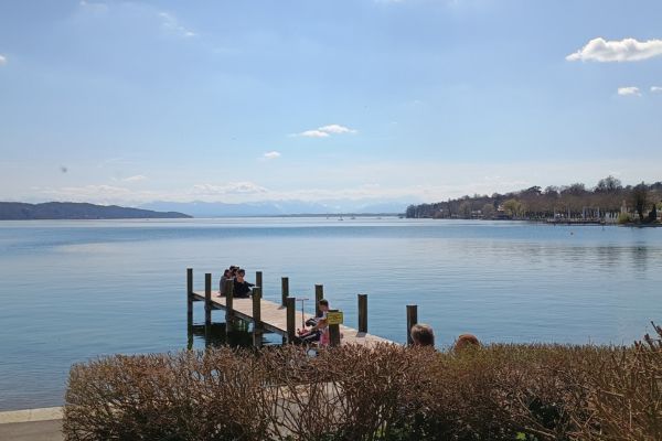
Along Lake Starnberg
This is the easiest (and easiest to access) option of all the walks listed here. Lake Starnberg is long and has (mostly unpaved) walking trails on the lakeshore in many places. The lake has a circumference of 49 kms/30 miles.
To make it super easy, catch S6 or a regional train to Starnberg and walk 50 yards from the station – you are right by the lake.
I really enjoyed the walk from Bernried (the Buchheim Museum is well worth a visit; it hosts the private art collection of the man who wrote the novel „Das Boot“) to Tutzing.
How to get there: S6 stops at Starnberg, Possenhofen, Feldafing and Tutzing. Some local trains also stop at Starnberg and Tutzing, as well as Bernried.
Around Staffelsee
Staffelsee is located south of Starnberger See, on the way to Garmisch. The walk along its shore and through the marsh is flat, but long: 17 kms/around 12 miles if you walk from the town of Uffing to the town of Murnau. The walking time should be about four hours. You can also continue to Uffing for a full circuit, which would add another hour to your walking time. Along the way, you will walk through a variety of landscapes and will be able to see lots of plants and small animals.
There are no refreshment stops along the way, but you will find cafes and restaurants in Uffing and Murnau. In Murnau, you can visit the Münter Haus, where Gabriele Münter and Vassily Kandinsky lived.
How to get there: Take a local train to Garmisch and alight at Uffing or Murnau.
Good to Know
German Place Names
Confusion alert: „See“ in German means „lake“. Thus, „Starnberger See“ literally means „lake of Starnberg“. In Germany there will often be a small town that bears the same name as a lake. For instance, „Tegernsee“ refers both to the lake and to the town on the southeastern edge of the lake.
An „Alm“ is a summer pasture and up in the mountains. Cattle are driven to these summer pastures once the weather becomes suitable, usually around Pentecost. They spend the summer on the Alm before being driven back down into the valley as the weather turns colder. Many working Alms provide simple meals and beverages, usually as a side business. Some may also be fully geared towards hospitality.
Hiking Footwear
The hikes and walks I mention here are usually easy hikes, meaning the trails are in good condition, there is ample signage etc. However, the hikes are still hikes and they can be steep. That means you will need suitable footwear that gives you good traction.
Do not attempt to go on a hike wearing flip-flops, sandals, or heels! Trainers/running shoes are the bare minimum, but not ideal, as they give you no ankle protection (they are ok for Staffelsee and some Starnberger See routes). Dress shoes are suitable for paved areas only.
Hiking Signage
All official hiking trails are clearly marked with yellow arrows.
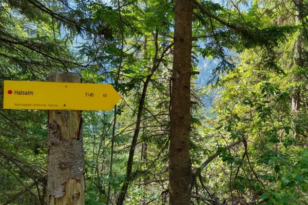
The arrows indicate:
- how difficult the trail is (by the color of the dot on the left),
- the destination – in this case, Halsalm,
- the estimated walking time – in this case, 1 hour and 15 minutes,
- the trail number.
Hiking Safety
For any hike, make sure you know your route, carry enough water and charge your phone. If you are going into the mountains, remember the weather can change in an instant. Check the weather forecast, and make sure to carry warm clothes.
You will most likely not have mobile reception in the mountains!
Hiking Apps & Maps
The most popular apps for hikers seem to be Komoot, AllTrails and Outdooractive.
These apps are great for researching hikes. Remember, however, that their content is user-generated. Therefore, you may find the same hike described several times, with widely varying hiking times and degrees of difficulty. You don’t know how the author’s fitness and alpine-skill level compare to yours, so do be very careful. We have heard more than one story of people having to be rescued in the middle of the night because they took an „easy 3-hour hike“ they found on an app – and that turned out to be a hard, 7-hour hike for them.
If in doubt, get some informed advice. The German Alpine Club’s local chapter München & Oberland has service centers in the Globetrotter and Sport Schuster stores in Munich. Go there and ask them about the hikes you are considering.
It makes sense to get an up-to-date hiking map before you set out. These can be purchased from the Alpine Club service centers or from the Hugendubel book shop on Marienplatz. The Alpine Club only sells its own maps. Hugendubel has maps by other publishers too. Check out a few to see which one works best for you.
Finally, if you go to the tourist information desk in the towns from which you are starting out, they will have the latest information. Sometimes a trail is washed away in bad weather – the locals will know it, the staff at Hugendubel probably won’t.
Happy Hiking!
Ein Kommentar